From autonomous navigation in GPS-denied orchards to crop health monitoring across millions of acres — LexData provides the precision annotation and continuous intelligence that agricultural AI needs to work in the real world, not just the lab.
Autonomous farm equipment loses positioning under tree canopies, in dust, and in low-light conditions. Visual navigation is the only option — but it needs labeled data to work.
Crop growth, seasonal shifts, weather, and soil conditions change the visual environment weekly. A model trained on spring data degrades by summer. Static training sets can't keep up with living environments.
Large-scale farming operations depend on manual scouting for disease, weeds, and yield estimation. It's costly, inconsistent, and doesn't scale.
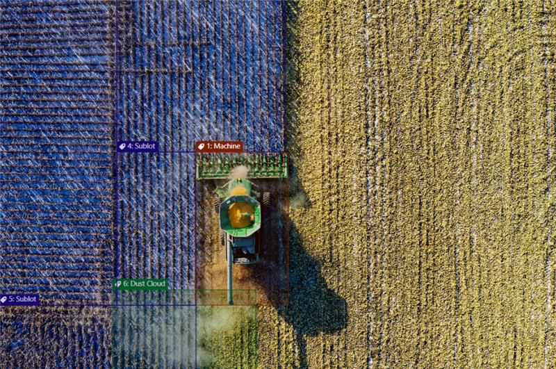
Annotate crops, equipment, obstacles, and pathways with polygons, polylines, and semantic segmentation. Tag environmental factors like dust, shadows, and occlusions. 80k+ images annotated in production deployments.
Transform plant-level detections into field-level intelligence. Map disease patterns across zones, track crop health progression over time, estimate yield from visual data.
Monitor autonomous navigation models against seasonal drift. Retrain as fields change. Maintain 95%+ navigation reliability in changing environments.
Early visual identification of pests, fungus, and nutrient deficiencies.
Precision targeting for automated weeding and herbicide reduction.
Visual SLAM and obstacle avoidance in unstructured terrain.
Automated fruit/plant counting for accurate harvest forecasting.
Precise mapping of plantable areas vs. obstacles and pathways.
Health and activity tracking for herd management.
Unreliable GPS under tree canopies and low visibility. Models failed in unstructured, obstacle-heavy terrains.
Annotated thousands of images with polygons and polylines. Tagged diverse environmental factors like dust, shadows, and occlusions.
Enhanced autonomy in GPS-denied environments. Faster deployment of AI-powered navigation.
"Semantic segmentation for complex outdoor environments — not just bounding boxes."
"Continuous retraining as fields change seasonally. Your model never goes stale."
"Edge deployment for field equipment with limited connectivity."
"Proven at scale with Bonsai Robotics for autonomous farm navigation."